Showing posts with label Vancouver Island. Show all posts

Wednesday, July 19, 2017

Ladysmith - Kayaking, Boom Boats, Log Booms

Yesterday (2017-07-18) was a kayaking day. I launched into Ladysmith harbour and decided to explore in and around the Woods Islands that lie opposite the city. The pictures in this post are a bit of a departure from my usual scenic landscape photos. That's because, beyond scenic seascapes and landscapes, I find it hard to resist boats. Especially working boats. Lucky for me, the harbour was abuzz with boom boat activity. I reckon, on my trip this morning, there were close to twenty such boats working the many booms that seem to encircle Woods Islands.

I've always thought I'd like to operate a boat like this...

Boom boat pushing logs about near Ladysmith sawmill...

Boom boat seemingly rearing up...

Boom boat: different colour; different company...

A tugboat working a log boom along the shore of Woods Islands

Boom boat working the passage between Woods and Vancouver Islands...

Note the preponderance of log booms along my route...

Thursday, July 13, 2017

Long Beach - Chesterman Beach

Sabrina's recent visit seemed like as good an excuse as any to spend a few days in Pacific Rim National Park. As part of this outing, we spent a few hours wandering about on Chesterman Beach (2017-06-28).

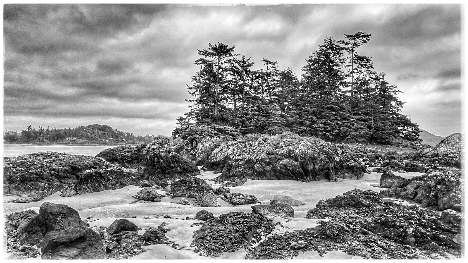
Frank Island off Chesterman Beach. Sometimes black and white photographs also look good, I reckon.

At low tide, Chesterman Beach presents a vast, sandy beach...
Human ingenuity uses available materials (drift logs) to create a useful bench...

The rock-water interface often teems with sea life...

Saltwater pools with sea life - in this case, sea anemone...


Sunday, February 21, 2016

Bamfield slideshow

In October of 2014, we spotted an advertisement in the local newspaper for reduced-fare trips to Bamfield (from Port Alberni) on the packet freighter, MV Frances Barkley. At about $35 per person, how could we resist? Quite simply, we couldn't!

So, on the last day of the offer, (2014-10-30), we took the day trip. What started as a slight drizzle earlier in the day, turned itself into a full fledged monsoon by noon as a docked in Bamfield. Suffice to say, I lost a camera to that downpour.

Without my Sony cellphone (advertised as waterproof), there'd be no pictures for this slideshow.

To see the captions, move the mouse over the slideshow.


Monday, April 6, 2015

Long Beach - A trip in February

It's February. Not a good time of year to travel to the west coast of Vancouver Island, you'd think. WRONG! In our mind, ANYTIME is a good time for a visit to Ucluelet, Tofino and Long Beach.

Follow the rest of our trip report on the captions to the pictures...
  • 2014-02-01 
  • 48.923, -125.537
Compulsory stop at the water rushing past islands of rocks near Wally Creek.  Parking and access has been made easy.  However, DON'T attempt to walk about the rocks if they're wet!
Compulsory stop at the water rushing past islands of rocks near Wally Creek.
Parking and access has been made easy.
However, DON'T attempt to walk about the rocks if they're wet!


Once we arrived in Ucluelet, we had enough time for a short walk  along the Wild Pacific Trail to the lighthouse at Amphitrite Point.
Once we arrived in Ucluelet, we had enough time for a short walk
along the Wild Pacific Trail to the lighthouse at Amphitrite Point.

A good view of what is known as the "Graveyard of the Pacific"
Amphitrite Lighthouse on the Wild Pacific Trail


Sunday, December 8, 2013

November At Whippletree Junction

Today's photos (2013-11-23), are mostly about whimsy. The whimsy that is  Whippletree Junction, just south of Duncan, BC. After a recent trip to Victoria, on our way back home, we turned off the highway for a cup of coffee and another look. There's little doubt; a great place for photos of old, colourful buildings.
Gift shop at Whippletree Junction (2013-11-23)
 The early afternoon November sun was low enough spotlight the brightly coloured buildings that make up Whippletree Junction; great for photos. Of course, as this was November, we didn't expect to see much custom in the various stores. There wasn't. In fact, but for a few people in a couple of the furniture emporiums, the place was deserted.
 Colourful shop exteriors at Whippletree Junction (2013-11-23)
 Colourful shop exteriors at Whippletree Junction (2013-11-23)
 Wandering about this deserted place, I found myself asking, "Why?" Why does this place even exist? Why are there no customers? It couldn't entirely be the lateness of the season. Just weeks earlier we'd driven by the venerable "Goats on the Roof" set of stores in Coombs and there were plenty of customers. The question: "What does Coombs have that Whippletree doesn't?" It can't just be goats on the roof, can it?
Stop for a coffee at Whippletree Junction (2013-11-23)
 Whippletree Junction looks neglected. It certainly looks like it needs an infusion of cash. And an infusion of ideas. Enthusiasm, perhaps. Clearly, a bunch of quaint old, brightly coloured, faux-whimsical buildings are not enough to draw Coombs-like custom.
Shopping at Whippletree Junction (2013-11-23)
 Luckily, Whippletree Junction is not my problem. It is, on the other hand, a place where my camera can work overtime!
Shopping at Whippletree Junction (2013-11-23)
 Hopefully business will pick up during the pre-Christmas season...
Shopping at Whippletree Junction (2013-11-23)
 Colours galore...
(2013-11-23)

Colourful whimsey at Whippletree Junction (2013-11-23)


Saturday, September 28, 2013

French Creek in September

I have a fascination with boats, ships, and all things nautical. French Creek is always an attraction for exactly those reasons. And, if a mid-September day is pleasant, French Creek is all the more worthy of a photo excursion. On this particular day, along with the usual assortment of boats to be encountered, my attention was drawn to miscellaneous "nautical knots and dockside details".

The characteristic red railings of the government dock at French Creek (2009-09-15)
The characteristic red railings of the government dock at French Creek (2009-09-15)


Knotted dockside details (2009-09-15)

The vessel "Patrol No 1" showing her good side (2009-09-15)

Jerry-rigged nautical details(2009-09-15)
Jerry-rigged nautical details (2009-09-15)

Rusty nautical details (2009-09-15)

MV Cape Cockburn of the Canadian Coast Guard (2009-09-15)

Thursday, September 26, 2013

All's Quiet at Genoa Bay

One of our favourite day excursions is a trip to Genoa Bay. Primarily, we go for the excellent food served at the Genoa Bay Cafe. But, the drive through Ladysmith, Chemainus, Crofton, and Maple Bay has a charm of its own. And, of course, the winding road that connects Maple Bay with Genoa Bay is always fun to drive; particularly in the fall when autumn colours brighten the journey. On this particular visit, in  May, things were awfully quiet in the bay. Clearly, the boating season was just beginning and the docks weren't nearly as full as we've seen during summer months. Nonetheless, Genoa Bay is also worth a visit in the "off season". In my opinion, if you love Vancouver Island as much as I do, there's never an off season!

Cute houseboats line the Genoa Bay docks (2009-05-05)

In May; not many boats moored at Genoa Bay (2009-05-05)

Are these "boat houses" or "boat garages"? (2009-05-05)


All's quiet on the Genoa Bay Cafe deck (2009-05-05)

Clearly an area waiting for the summer season to arrive (2009-05-05)


Monday, September 23, 2013

At the End of Royston Road

A while ago, I posted Royston's Red Railing to my blog, A Postcard from Vancouver Island.

I liked the colour and the perspective of this little pier at the end of Royston Road, where it intersects with Marine Drive, and I thought I'd share some of the other pictures taken around the same time.

The view here is of Comox (Port Augusta as it was known in earlier times - circa 1860).

Little pier right at the end of Royston Road (2011-08-10)
Little pier at the end of Royston Road (2011-08-10)


A view of the Salish Sea from Royston (2011-08-10)

Sailing school in Comox (2011-08-10)

Park at the end of Royston Road (2011-08-10)

Thursday, September 12, 2013

Chillin' Parliament at Clover Point Park in Victoria

We were down in Victoria on this particular November because.... Well, does one need a reason to visit Victoria?!

Anyway, the day's meanderings eventually, somehow, lead us to Clover Point Park. It was November. The sun was out. All was right with the world. Time to take some pictures.

Enjoy...

Seagulls sunbathing at Clover Point Park (2012-11-14)

Houses along Victoria's Dallas Road as seen from Clover Point Park (2012-11-14)
Houses along Victoria's Dallas Road
as seen from Clover Point Park (2012-11-14) 

When is beach "stuff" not worthy of a quick CLICK? (2012-11-14)
When is beach "stuff" not worthy of a
quick CLICK? (2012-11-14)

The houses of Hollywood Crescent from Clover Point (2012-11-14)
The houses of Hollywood Crescent from
Clover Point (2012-11-14)


Sunday, August 11, 2013

Scenes at the Tofino Dock on a Rainy May Day

A rainy day in May at Tofino (2013-05-27)

Enjoy this trip report in pictures!

Wet, rainy dock in Tofino (or any place Wet Coast BC)


Across the water, Opitsaht... a community of the Tla-o-qui-aht people of the Nuu-chah-nulth nation, located at the SW end of Meares Island
Across the water, Opitsaht...
a community of the Tla-o-qui-aht people of the Nuu-chah-nulth nation,
located at the SW end of Meares Island


Does it get any more WEsT Coast than this?


A touch of colour on an otherwise grey day in Tofino


Quintessential West Coast


Mountains, shrouded in mist


Thanks for the visit!


Saturday, August 10, 2013

Kayaking the Flat Top Islands out of Silva Bay on Gabriola Island

(NOTE: The blog is called Vancouver Island in Pictures. This post is about the Flat top Islands off Silva Bay, on Gabriola Island. I choose to interpret "Vancouver Island" rather broadly. My assumption is, if the residents of a Gulf Island are served by one or more of the four post secondary institutions located on Vancouver Island, then that's good enough for me. I too will consider these islands as part of Vancouver Island.)

Before kayaking at some new location, I find it useful to determine what launching will be like. Thus, I occasionally deliberately scout out potential locations. At other times I keep a look out for possible sites. So it was as Hanne and I were driving along North Road after a nice lunch at Silva Bay Marina.
Small gap in the bushes off Westgyle Road;  good enough to launch a kayak
Small gap in the bushes off Westgyle Road;
good enough to launch a kayak
Out of the corner of my eye, looking down Westgyle Road, I spotted a couple of kayakers pulling two kayaks out of what seemed like bushes. This called for further investigation. It turned out that there was a small gap in the bushes, leading to a gravel beach. Beyond a narrow strip of gravel, punctuated by the occasion log, lay a few meters of mucky, low tide sludge. 


The kayakers assured me that this was a good place to launch a kayak. It looked good to me. They also extolled the merits of kayaking around the Flat Top Islands.


The “launch” requires pulling the kayak down what must be about a 45-degree incline over mostly dried mud and some rather smooth roots The shore itself is coarse gravel for about 5 meters, followed by “muck”. More on that later
The “launch” requires pulling the kayak down
what must be about a 45-degree incline over
mostly dried mud and some rather smooth roots
The shore itself is coarse gravel for about 5 meters,
followed by “muck”

Perfectly calm in even the stormiest weather, they said. I promised myself to come back to give it a try.

In July of 2010 Britta and I set out for Gabriola Island. After catching the ferry from Nanaimo and a little breakfast in downtown Gabriola, we arrive at our launch site at Silva Bay. It was a “lowish” tide. More on that later.

We launched without incident and started our leisurely paddle away from the shore.  Before leaving home, I'd taken out the charts we needed. And promptly left them in the living room. We were now “navigating” by the Chamber of Commerce map we picked up at the ferry terminal. Generally, that's not good practice.

Check out the last picture in this post to see why checking tide tables and checking potential launching sites at all possible tides is a good idea.

Enjoy our story in pictures:


While I schlepped the kayak to the water's edge, Britta waited at the bottom of the 7 meter slope with the kayaking paraphernalia
While I schlepped the kayak to the water's edge, 
Britta waited at the bottom of the 7 meter slope 
with the kayaking paraphernalia

AD AD
Having rounded Law Point,  we hug the Gabriola Island shore.  We can't tell if this route will take us into a bay,  or if there's a gap ahead
Having rounded Law Point,
we hug the Gabriola Island shore.
We can't tell if this route will take us into a bay,
or if there's a gap ahead


Is this a bay, or can we get out?
Turns out, there's a gap ahead (Lily Island to the right)

Along the Gabriola shore, the characteristic sandstone; this time with cannonball-sized holes. Perhaps where concretions dropped out over time
Along the Gabriola shore, the characteristic sandstone; 
this time with cannonball-sized holes. 
Perhaps where concretions dropped out over time

Through the gap, and  straight ahead lies Carlos Island
Through the gap, and
straight ahead lies Carlos Island

A yellow kayak (not ours) on Carlos Island

Beautiful milky-coloured ground (plenty of broken clam and oyster shells) beneath the water off Carlos Island

Little bay on eastern shoreline of Vance Island beckons to be explored

Looking past Gaviola Island (Rowboat Point) into the Strait of Georgia *   **
Looking past Gaviola Island (Rowboat Point) into the Strait of Georgia


From the southern shore of Acorn Island, we look west, past Shipyard Rock, and into Silva Bay
From the southern shore of Acorn Island, we look west,
past Shipyard Rock, and into Silva Bay


Britta noted a distinct fishy odour about.  Seal poop? Seal breath? Who knows?
Britta noted a distinct fishy odour about. 
Seal poop? Seal breath? Who knows?


Upon leaving our seal friends, we paddled over to Bath and Saturnina Islands (three kayaks and people enjoying lunch on the tombolo)
Upon leaving our seal friends, we paddled over to Bath and 

Saturnina Islands (three kayaks and people enjoying lunch on the tombolo)

Seals watch us drift by; an Oyster Catcher  takes care of business in the background
Seals watch us drift by; an Oyster Catcher 
takes care of business in the background

Cute cabin on the shores of Sear Island

The captain's chair on Tugboat Island


A narrow gap will lead us into the Silva Bay anchorage

Silva Bay Shipyard School.
Silva Bay Shipyard School

As we pull the kayak through the muck, Britta feels a tiny crab in her shoe. She screams. The next time we look, this deer is gone
As we pull the kayak through the muck, Britta feels a tiny crab in her shoe.
She screams. The next time we look, this deer is gone!

This picture gives only a partial indication of what distance we had to pull the kayak. There was no thought, ever, of carrying it, as we would have sunk too deeply into the mud!
This picture gives only a partial indication of what distance we
had to pull the kayak. There was no thought, ever,
of carrying it, as we would have sunk too deeply into the mud!